IOTA set for near category five landfall
From west to east;
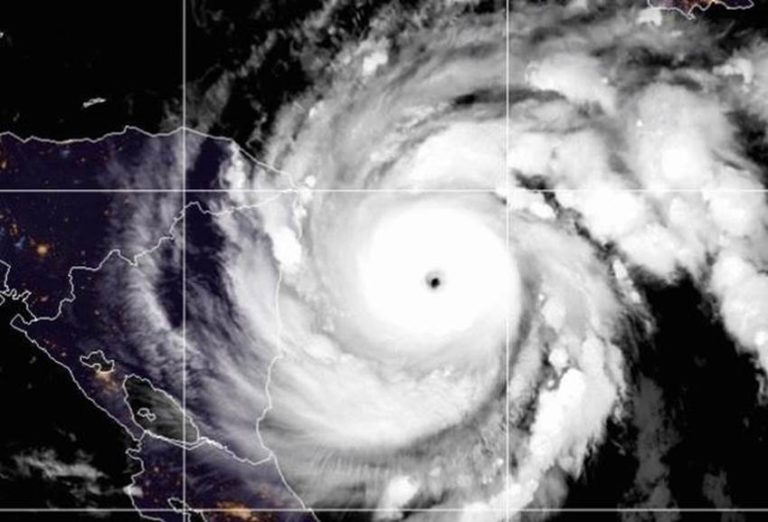
Reconnaissance flights buzzing hurricane IOTA are bringing back precious little news of comfort. Two flights six hours apart reported zero wind shear, a staggering barometric fall of 26 millibars in 6 hours, an increase in wind speed around the 15 mile-wide eye of almost 40 knots in the same time period and a near-perfect convection cycle. This is a ruthless storm. Currently 130 miles east-sou’east of Puerto Cabezas, Nicaragua, moving west-nor’west at 8 knots this has landfall in its sights this evening as tropical storm force winds are already brushing the coast. With a current hurricane intensity index rating of 24 (8 for size and 16 for intensity) this is at category 4 now, and with the current rate of intensification, is likely to reach category 5 at landfall with an HSI of 29 (8 for size and 21 for intensity) producing 150 knot gusts and a destructive storm surge. As this is slow-moving, the impact ashore will be protracted and heavy rainfall from IOTA will lead to life-threatening flash flooding and river flooding across portions of Central America. Flooding and mudslides in Honduras and Nicaragua will be exacerbated by the effects of Hurricane ETA resulting in significant to potentially catastrophic impacts.
I picked up a couple of days ago on a disturbance shaping up in the Caribbean to the north of Colombia which may have a development window towards the middle of the week and threaten southern Nicaragua as a tropical storm. I chose to ignore this in the hope it might go away. It hasn’t.
THETA dissipated in the east central Atlantic and is off our radar now.
Stand by for very powerful hurricane conditions in the north-western Caribbean.