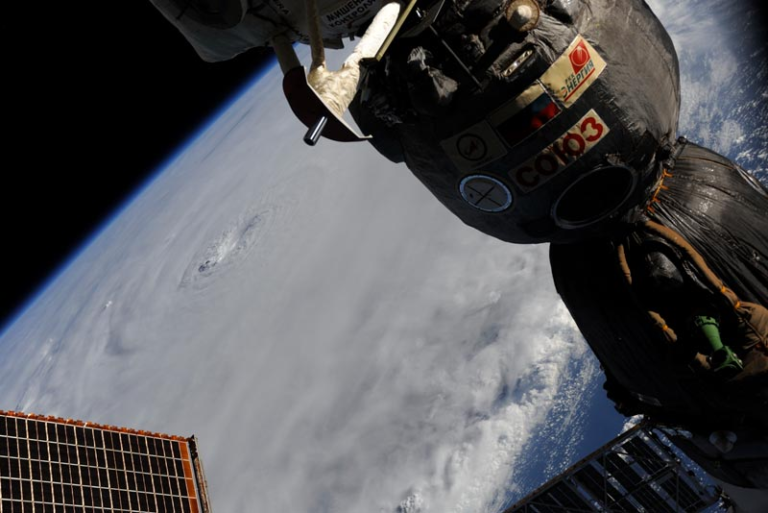
EARL set to pass Bermuda as a major hurricane…

From west to east;
Ground acceleration and upper level wind shear is hastening the demise of DANIELLE. The storm is losing its convection column and eye wall replacement has ceased. Aerial imagery would seem to indicate that the DANIELLE is no longer a hurricane but still has estimated maximum wind speeds of 60 knots. Currently 500 miles north of the Azores, one or two modellers have this meandering slightly, but it is more likely that this will now take the well-worn exit path to the north-east. There is some chatter of this maintaining some energy and taking a swipe at western Europe, and the Canadian Guy is of course at the forefront of that. Make of that what you will.
There are some crumbs of comfort for the good people of Bermuda today. Currently 270 miles a tad east of due south of Bermuda, the hurricane has turned slightly to the east of north, has picked up speed to 12 knots and a passing distance at closest point of approach is beginning to appear. In addition, there is a layer of westerly upper level wind shear which is pushing some of the muck and filth to the east. With winds gusting over 100 knots and a tropical storm force windfield radius of 160 miles, this has a hurricane severity index (HSI) rating of 17 out of a possible 50 points (9 for size and 8 for intensity) This is still a nasty storm and has more nastiness up its sleeve. EARL now has a well-defined eye of around 30 miles in diameter with a robust eye-wall replacement cycle going on, the puff of wind shear won’t last long and there is warm water below. This will allow further development to a possible category four hurricane in around 24-36 hours’ time, probably soon after passing Bermuda. The key question now is passing distance and the smart money is on a closest point of approach of between 50 and 100 miles. As the peak intensity is expected have an HSI of 32 (16 each for size and intensity) which equates to winds touching 150 knots and a tropical storm windfield radius of over 300 miles, this passing distance whilst welcomed, does still mean that tropical storm force winds can be expected on the island as early as this afternoon. Hurricane-force winds are possible over Bermuda this evening or tonight if the track shifts farther west than is currently forecast. Swells generated by EARL are building near Bermuda and are expected to reach the eastern seaboard later today.
Disturbance Twenty Seven has been absorbed by DANIELLE and is off radar.
Disturbance Twenty Nine is now centred 950 miles west-nor’west of the Cape Verde Islands moving to the west-nor’west at a brisk 18 knots. This is well to the north of the tropical convergence zone and despite having a well-defined circulation, is entering an area of strong vertical wind shear which will hamper any serious development and reduce its survival chances.
Disturbance Thirty is passing to the south of the Cape Verde Islands and is quite poorly organised. Despite this having been written off by most observers, this still has a glint in its eye and I would not write it off.
Stand by for hurricane conditions approaching Bermuda and tropical storm force sweeping the islands.