Munich Re Syndicate 2024 Atlantic, Caribbean & Gulf of Mexico storm season. Stand by Engines.
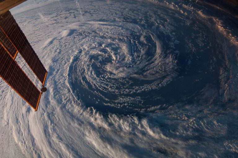
Image Patti Rhodes
Welcome to our traditional preamble to our daily bulletins for the Atlantic basin, Caribbean and Gulf of Mexico storm season 2024, with my profuse apology for missing the entire 2023 active period. I would offer my sincere thanks for the many kind messages received.
This is our sixteenth (out of seventeen) year of reporting and now goes to over 1,000 readers on a single email with close to 10,000 followers on social media platforms and more picking it up on our website www.watkins-marine.com. This is a free service and distributed without restriction. If you would like colleagues or friends to be added to the list, please contact me onamccourt@munichre.com and I will add them to the list.
New readers will be horrified at the length of this email. Please rest assured that this is by far the most I would expect anyone to read. You will be relieved to know that we normally get the daily report done in a paragraph or two.
This started life as a daily, very brief, easy-to-read and when appropriate, light-hearted bulletin for the energy team at then Watkins Syndicate, now Munich Re Syndicate. As more colleagues asked to be added, we began to receive requests from third parties, initially brokers then other underwriters. Now we have a wide range of addressees including offshore operators, CEOs, superyacht Captains and owners, fishermen, drillers and assorted seafarers, both leisure and professional, and more recently joined by those with interests in renewable energy and US property. All are welcome but should take heed of my words of caution. Every year, I make it absolutely clear with the cynicism of an old sailor, that I hold long-range forecasts in absolute contempt. I don’t trust weather forecasts and nor should you, least of all mine. I have spent far too much time at sea up to my knees in green water, being slung around like a pea in a drum and trying to hang on to my breakfast, while someone safely tucked behind a faraway desk assures me that I am having a fine day.
Sixteen years of this has taught me that I’m no smarter now than I was when I was dodging storms for a living. The old adage of the more that I learn, the less I know, has never been so true. I do however have a personal rule of thumb for the North Atlantic (and United Kingdom latitudes) in winter. 24 hours is probable. 48 hours is possible. 72 hours is guesswork. 96 hours is nonsense. To a degree, we can apply that to the tropical Atlantic, Caribbean and Gulf of Mexico when considering cyclone tracks. I have another tip for those committed insomniacs who are interested in the weather at sea. Listen to the UK Met Office forecast in the summer sailing months and subtract two points from the Beaufort wind force to get a true picture. Ever since they were panned over the 1979 Fastnet disaster, this has been a good rule of thumb. An unofficial safety margin. Totally deniable of course. I digress…..
Throughout the season, we maintain a continuous overview of weather charts and listen to the ever-changing opinion of professional agencies, smart analysts and vile weather enthusiasts, then throw in our own hunches to produce a regurgitated opinion. We take a quick shufti at the overnight charts each morning then the early reports from the US agencies around midday before producing our own, which usually then goes out early in the afternoon UK time. The nominal start to the Atlantic, Caribbean and Gulf of Mexico season is June 1st and ends on November 30th. For the last few years, that was stretched at both ends. The last few seasons have all had an early start hence this summary is being published early. Once ALBERTO appears (or threatens to), we’ll begin our daily bulletin. Thereafter, for every day throughout the season, our aim is to provide a daily simple, plainly worded and – one hopes – reasonably sound forecast.
I have been unfairly accused of accuracy in four of the past six seasons. It is neither my intention or desire to be accurate with forecasting season’s figures but with some pressure from readers, and with more than a whiff of suspicion that there are some sweepstakes being held, I’ll take a stab at an annual prediction. I have to add with a degree of gloomy reluctance, nobody is expecting an easy season.
Increasing uncertainty based on freak weather becoming less freak and more mainstream has had the modellers all over the place for this year’s forecast again. I always like to look at Colorado State University at this time of year for sound reasoning. CSU has produced their most aggressive forecast since they began their pre-season estimates 30 years ago, citing above normal confidence for a meaningful estimate in April. They are predicting 23 named storms, 11 hurricanes and 5major hurricanes. This is significantly higher than average and is based upon the current El Niño transitioning to neutral and an anticipated La Niña developing in the late spring (falling air over the Pacific, rising air over the Atlantic).
To add to the lusty storm outlook, there are some eye-watering sea temperatures being reported across the tropical Atlantic. Indeed, water temperatures across the entire convergence zone from the Gulf of Mexico almost all the way to the African coast are already well above normal for this time of year and close to what would be expected in peak summer. Warm water, as we know, is storm fuel and may fire up an early development to the east of the Caribbean, upper level wind shear permitting of course. This will weaken the seasonal Bermuda High pressure zone and take the sting out of the trade winds, decreasing wind shear, inevitably increasing hurricane risks to the islands of the eastern Caribbean.
The respected CSU team has gone one step further with (in my humble view) a rather audacious stab at a major hurricane landfall risk compared to averages calculated over 140 years from 1880 to 2020. Their prediction is for a 64% possibility anywhere along the entire US continental coastline compared to a 140 year average of 43%, a 34% possibility over the Florida peninsula compared to an average of 21% and for the Gulf coast from Florida to Brownsville of 42% compared with an average 27%. A major hurricane sweeping across the Caribbean is predicted at a 66% possibility compared with an average of 47%.
We have checked some of the more reliable European agencies whose predictions are generally more conservative, but they too are predicting a busy season, averaging around 18 – 20 named storms. The US National Hurricane Centre is rather stand-offish about early season predictions and has yet to reveal any deep and meaningful figures but is describing the forthcoming season as ‘concerning’. This is not good news at all.
To get to the point, on the basis of one guess being as good as any other, my reluctant prediction is to go with CSU with slight moderation, for 22 named storms, 11 hurricanes and a slight increase to 6 major hurricanes. As ever, I hope this is a wild overestimation. I should add here that views, comments and predictions expressed in these reports are my own, and do not necessarily reflect those of the Syndicate.
Names this year are ALBERTO, BERYL, CHRIS, DEBBY (sic), ERNESTO, FRANCINE, GORDON, HELENE, ISAAC, JOYCE, KIRK, LESLIE, MILTON, NADINE, OSCAR, PATTY, RAFAEL, SARA, TONY, VALERIE and WILLIAM. Regular readers will recognise this as the list for 2018 with the exceptions of FRANCINE and MILTON, which the World Meteorological Organisation ruled should replace FLORENCE and MICHAEL. Both had catastrophic impacts and will never be used again for Atlantic tropical storms, joining 96 others in the sin bin which includes KATRINA, MITCH, HARVEY and IKE. It seems likely that this year’s list may be exhausted in which case, a supplemental list has been drawn up by the WMO which begins ADRIA (which would be the end of my precited season), BRAYLEN, CARIDAD and DESHAWN. I feel typing the entire list ending with VIVIANA and WILL would be seriously tempting providence. The tradition of using Greek characters for season overruns has been discontinued.
Many of you will recall that I draw information from a number of sources, varying from the reliable agencies such as the UK Met Office, a couple of Europeans and of course many US, particularly military, sources. In quiet times, I occasionally share a snippet from one of the more eccentric storm enthusiasts who can always be relied upon to see a cumulus cloud and predict Armageddon. One such observer is the now legendary Canadian guy, or my ‘Blind Sniper’, who seems to have acquired a popular following amongst you over the years judging from feedback received. He has had the odd success and cannot be totally disregarded but is only generally remarkable by fairly consistent inaccuracy. Two years ago, for the fifth year in a row, he tracked a storm which would have passed directly over my home in south-east England, giving me some cause to suspect that he is on to me and knows where I live.
Thanks to the many of you who read our daily blurb who kind messages of thanks and feedback at the end of the 2022 season, particularly the growing Blind Sniper Fan Club, and once again, my apologies for skipping 2023. Feedback is always much appreciated. I think we have replied to all, as indeed I endeavour to do throughout the season. Please note that I can only access incoming mail replies to the daily report when I am in London, but I often travel, which may mean a delayed reply, or they are simply submerged by e-mail flotsam which comes in with every internet tide.
I have enjoyed exchanges with many of you over the years which have been in some cases, quite heart-warming. Several years ago, I was contacted by a Police Officer in Georgia who had apparently been an avid reader for some years and wanted to thank me for the pleasant weather on the day of her husband’s funeral. ‘Happy to do my bit, Ma’am’. Last year I had a delightful message from a seagoing Master who expressed thanks for my ‘holding his hand over multiple Atlantic crossings for a number of years’. I’ve been a Master myself and despite a good few years driving a desk, still think of myself as a seaman at heart and know the value of a friendly word from an old hand in an otherwise lonely place. I am always touched by such messages.
I have for some years said that each season may be my last, which has seemingly become as wearily predictable as a Status Quo farewell tour, so I will only say that this may be my final season. Again.
Stand by engines for the 2024 Atlantic, Caribbean and Gulf of Mexico storm season.