NICOLE ashore in Florida.
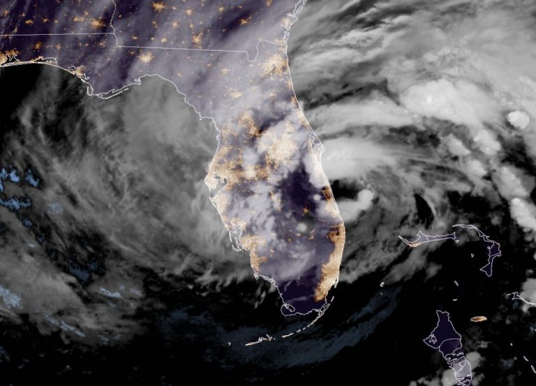
Hurricane NICOLE made landfall at 0300 local time close to the south of Vero Beach as a lower strength category one hurricane producing winds touching 85 knots and a tropical storm force windfield of 235 miles which equates to an HSI rating of 10 (5 each for size and intensity). Not great news but a few final wobbles took the edge off the cyclone and considerably reduced its radius and whilst not dismissing its impact, NICOLE may prove to be a dodged bullet. Once ashore, NICOLE headed west-nor’west at 15 knots and quickly degraded to a tropical storm. High pressure to the north will turn the cyclone to the north-west and then to the north-east, accelerating and weakening as it does so. Although the nominal centre may emerge over the extreme north-eastern Gulf of Mexico early this afternoon, this will be short-lived and won’t inspire intensification. Continued weakening is expected thereafter while NICOLE tracks over the south-eastern United States before merging with a frontal system by Saturday. Despite defeating the gloomiest forecasts, NICOLE will still cause tropical storm conditions to spread north along the west coast of Florida to the Florida panhandle through the day and a dangerous storm surge is expected along portions of the east-central and north-eastern coast of Florida, portions of coastal Georgia, and the Florida Big Bend along the Gulf coast which will be accompanied by damaging waves along the Atlantic coast. NICOLE will also produce heavy rainfall today across the Florida peninsula with flash flooding in places.
Stand by for tropical storm conditions across the northern Florida peninsula.