Category One hurricane FIONA ashore over the Dominican Republic
From west to east:
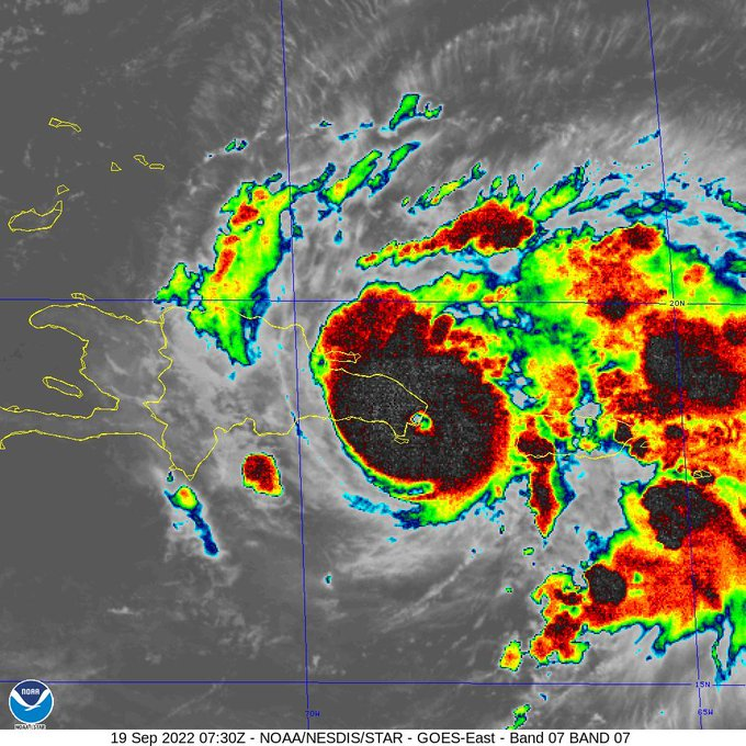
Category One hurricane FIONA is currently over the north-eastern Dominican Republic headed north-nor’west 7 knots. This is a powerful storm producing winds touching 95 knots with a tropical storm windfield of 100 miles which equates to a hurricane severity index (HSI) rating of 8 out of 50 (3 for size and 5 for intensity). FIONA is currently most notable for its significant amounts of rainfall which is already causing flooding over the Dominican Republic, reportedly severe in places. After FIONA moves back offshore this afternoon, it will quickly strengthen over warm water and is expected to become a major hurricane north of the Turks and Caicos Islands overnight on Tuesday. At this time, it is expected to reach an HSI rating of 26 (14 for size and 12 for intensity) which is likely to reach wind speeds of 120 knots with a tropical storm force windfield radius of over 250 miles. Looking ahead, FIONA is likely to brush Bermuda with hurricane force winds on Thursday and shape up for Newfoundland, still as a powerful cyclone.
Disturbance Thirty One is well to the north of the convergence zone, around 1,100 miles east-sou’east of Bermuda headed north at 10 knots. This will move to the north-east over the next few days and pass west of the Azores overnight on Wednesday. This has a slight chance of developing into a tropical depression before it is absorbed into a frontal system later this week over the north Atlantic.
Disturbance Thirty Two is three days east of Trinidad moving west at 16 knots. No development is expected before it reaches the Windward Islands on Thursday. At the moment, there is little certainty of its track and development once it enters the Caribbean. Lookout needed.
Stand by for continued hurricane conditions and very heavy rainfall across the Dominican Republic.